Tomorrow I go back on the road, and despite the title of this blog, I may not post until I get home. It's not that there is nothing to talk about. I am taking pictures all the time of things I eventually would like to discuss. The problem is 10 hour turns...
For example, last tour I had a very busy 6 days, during which I didn't write any posts - there was absolutely no time to sit down and write something coherent - and you deserve the best. Many people don't know this but most airline contracts allow "10 hour turns" from landing to the next takeoff. Some more generous employers allow 1/2 hour to an hour for the crew to close up the airplane at night and to prepare before a flight, but not usually. So this ten hours (which may come after the maximum 14 hour duty day) must include packing up your things from the airplane, dealing with the FBO, calling the hotel van (and often waiting for it), traveling to the hotel, checking in, settling into your room, ironing your shirt for the next day, etc. With all that has to be done in the morning to get yourself ready and back to the airport, you can imagine that a 10 hour turn rarely allows for 8 hrs of sleep, much less logging for blog posts. It makes a little easier to understand those hardworking pilots that dozed off into the sun on their way to Hawaii not too long ago. Doesn't forgive it, but we all have felt their pain. See CNN story on NTSB findings: http://www.cnn.com/2008/US/06/10/sleepy.pilots/index.html?eref=ib_travel
I'm going to keep trying though! Let me know if there is something YOU want me to talk about.
Monday, January 05, 2009


Saturday, January 03, 2009
The Conclusion
 Here's a picture of a fuel truck approaching that intersection we talked about earlier. I wouldn't want this vehicle to unload its contents into my airplane. This is a AVGAS (AViation GAS) truck, and jet engines require Jet Fuel. Avgas is currently available in several grades with differing maximum lead concentrations. 100LL Grade, spoken as "100 low lead", contains tetra-ethyl lead (TEL), a lead based anti-knock compound, but less than the "highly-leaded" 100/130 avgas it effectively replaced. Most piston aircraft engines require 100LL and a suitable replacement fuel has not yet been developed for these engines. While there are similar engines that burn non-leaded fuels, aircraft are often purchased with engines that use 100LL because many airports only have 100LL.
 Because of the danger of confusing the fuel types, a number of precautions are taken to distinguish between AvGas and Jet Fuel beyond clearly marking all containers, vehicles, and piping. AvGas is treated with either a red, green, or blue dye, and is dispensed from nozzles with a diameter of 40 millimetres (49 millimetres in the USA). The aperture on fuel tanks of piston-engined aircraft cannot be greater than 60 millimetres in diameter. Jet Fuel is clear to straw in colour, and is dispensed from a special nozzle called a "J spout" that has a rectangular opening larger than 60 millimetres in diameter so as not to fit into AvGas ports. However, some jet and turbine aircraft, such as some models of the Astar helicopter, have a fuelling port too small for the J spout and thus require a smaller nozzle to be installed in order to be refuelled efficiently.

Just like that Diesel pump at the local Gas station, just in case you're not paying attention when you pull up to a pump!
Speaking of filling up, there are many websites to let pilots know where they can buy the gas they need (and at what price!). Relieved that prices are going down where you live? Look at these fuel prices:
Average Fuel Prices By Region
Updated 01-03-2009
_________Jet A___ 100LL
_________Jet A___ 100LL
NC ______$4.35___ $4.37
NE ______$4.44___ $4.57
NW ______$4.23___ $4.70
SC _______$4.10___ $4.14
SE _______$4.22___ $4.20
SW_______$4.29___ $4.48
NE ______$4.44___ $4.57
NW ______$4.23___ $4.70
SC _______$4.10___ $4.14
SE _______$4.22___ $4.20
SW_______$4.29___ $4.48
At least you can fly farther on a gallon than drive...
Thursday, January 01, 2009
Part 4 of 5
 Finishing up with the runway, those white lights along the edge of the runway give the pilots information too. According to the pilot's "handbook," the Aeronautical Information Manual:
2-1-4. Runway Edge Light Systems
a. Runway edge lights are used to outline the edges of runways during periods of darkness or restricted visibility conditions. These light systems are classified according to the intensity or brightness they are capable of producing: they are the High Intensity Runway Lights (HIRL), Medium Intensity Runway Lights (MIRL), and the Low Intensity Runway Lights (LIRL). The HIRL and MIRL systems have variable intensity controls, whereas the LIRLs normally have one intensity setting.
b. The runway edge lights are white, except on instrument runways yellow replaces white on the last 2,000 feet or half the runway length, whichever is less, to form a caution zone for landings.
c. The lights marking the ends of the runway emit red light toward the runway to indicate the end of runway to a departing aircraft and emit green outward from the runway end to indicate the threshold to landing aircraft.
a. Runway edge lights are used to outline the edges of runways during periods of darkness or restricted visibility conditions. These light systems are classified according to the intensity or brightness they are capable of producing: they are the High Intensity Runway Lights (HIRL), Medium Intensity Runway Lights (MIRL), and the Low Intensity Runway Lights (LIRL). The HIRL and MIRL systems have variable intensity controls, whereas the LIRLs normally have one intensity setting.
b. The runway edge lights are white, except on instrument runways yellow replaces white on the last 2,000 feet or half the runway length, whichever is less, to form a caution zone for landings.
c. The lights marking the ends of the runway emit red light toward the runway to indicate the end of runway to a departing aircraft and emit green outward from the runway end to indicate the threshold to landing aircraft.
Believe it or not, if there is no tower personnel, so no one to turn on these lights, the pilots can do it for themselves (see chart).
Radio Control System
Key Mike____________Function
7 times within 5 seconds -Highest intensity available
5 times within 5 seconds -Medium or lower intensity (Lower REIL or REIL-off)
3 times within 5 seconds -Lowest intensity available (Lower REIL or REIL-off)
7 times within 5 seconds -Highest intensity available
5 times within 5 seconds -Medium or lower intensity (Lower REIL or REIL-off)
3 times within 5 seconds -Lowest intensity available (Lower REIL or REIL-off)
The control system consists of a 3-step control responsive to 7, 5, and/or 3 microphone clicks. This 3-step control will turn on lighting facilities capable of either 3-step, 2-step or 1-step operation. The 3-step and 2-step lighting facilities can be altered in intensity, while the 1-step cannot. All lighting is illuminated for a period of 15 minutes from the most recent time of activation and may not be extinguished prior to end of the 15 minute period (except for 1-step and 2-step REILs which may be turned off when desired by keying the mike 5 or 3 times respectively).
The green light you see there is from the airport beacon. Airport and heliport  beacons have a vertical light distribution to make them most effective from one to ten degrees above the horizon; however, they can be seen well above and below this peak spread. The beacon may be an omnidirectional capacitor-discharge device, or it may rotate at a constant speed which produces the visual effect of flashes at regular intervals. Flashes may be one or two colors alternately. http://www.halibrite.com/Beacon_refb_24_inch802A.html
beacons have a vertical light distribution to make them most effective from one to ten degrees above the horizon; however, they can be seen well above and below this peak spread. The beacon may be an omnidirectional capacitor-discharge device, or it may rotate at a constant speed which produces the visual effect of flashes at regular intervals. Flashes may be one or two colors alternately. http://www.halibrite.com/Beacon_refb_24_inch802A.htmlThe colors and color combinations of beacons are:
White and Green- Lighted land airport.
White and Yellow- Lighted water airport.
Green, Yellow, and White- Lighted heliport.
White and Green- Lighted land airport.
White and Yellow- Lighted water airport.
Green, Yellow, and White- Lighted heliport.
You can see the satelite view of the airport and it looks pretty easy to pick out. Who needs a beacon, right? Well, it doesn't just need to be dark to be hard to pick out an airport. Hazy weather conditions, surrounding buildings and streets, unfamiliar landscapes and the different perspective from being at a strange angle at altitude make it tough to find even large airports sometimes. A controller might tell a pilot, "Airport at your 12 o'clock and ten miles," and darn it if we can't see it until we're nearly on top of it!
Part 3 in the Series

I'd like to talk some more about the runway, with thanks to this Virgin Atlantic Airbus 340. We are looking at 19L at KIAD. The 19, btw, refers to the compass heading looking down this runway, minus the last digit. 190 degrees is close enough. Here are the precise numbers. The L, or left, means there is a parallel runway, or 19R. It's designated below, Runway 1R/19L because if you were facing the other way, you'd be looking approximately 010 degrees and there is also a 1L, which is the same piece of concrete as 19R. Perfectly clear, huh?
Runway 1R/19L
Dimensions: 11500 x 150 ft. / 3505 x 46m
Surface: concrete/grooved, in good condition
Weight bearing capacity: Single wheel: 200.0 Double wheel: 250.0
Double tandem: 450.0 Dual double tandem: 875.0
Runway edge lights: high intensity
RUNWAY 19L Elevation: 293.2 ft.
Gradient: 0.2%
Traffic pattern: left
Runway heading: 191 magnetic, 181 true
Markings: precision, in good condition
Visual slope indicator: 4-light PAPI on left (3.00 degrees glide path)
RVR equipment: touchdown, midfield, rollout
Approach lights: MALSR: 1,400 foot medium intensity approach lighting system with runway alignment indicator lights
Centerline lights: yes
Touchdown point: yes, no lights
Instrument approach: ILS/DME
Obstructions: 38 ft. pole, 1900 ft. from runway, 720 ft. right of centerline, 44:1 slope to clear
This runway, according to the diagram in a previous post and the above description is approximately 11,500 feet long by 50 feet wide. The white number just behind the landing Airbus is a 9 in a black box, signifying that there is 9000 feet of runway remaining. Above it talks about "Touchdown point."
The handbook for pilots is the Aeronautical Information Manual. It is a lot easier to read than the FARs (the federal regulations for pilots shortened from Title 14 of the Code of Federal Regulations) and has so much interesting and valuable information. There is so much to know about flying that it's easy for some information to fall out as more is crammed in.
For this post, I am looking at Chapter 2. Aeronautical Lighting and Other Airport Visual Aids, specifically, Section 3. Airport Marking Aids and Signs. and finally, 2-3-3. Runway Markings. http://www.faa.gov/airports_airtraffic/air_traffic/publications/atpubs/aim/Chap2/aim0203.html
This would be the markings on this runway.

d. Runway Aiming Point Marking. The aiming point marking serves as a visual aiming point for a landing aircraft. These two rectangular markings consist of a broad white stripe located on each side of the runway centerline and approximately 1,000 feet from the landing threshold, as shown in FIG 2-3-1, Precision Instrument Runway Markings.
e. Runway Touchdown Zone Markers. The touchdown zone markings identify the touchdown zone for landing operations and are coded to provide distance information in 500 feet (150m) increments. These markings consist of groups of one, two, and three rectangular bars symmetrically arranged in pairs about the runway centerline, as shown in FIG 2-3-1, Precision Instrument Runway Markings. For runways having touchdown zone markings on both ends, those pairs of markings which extend to within 900 feet (270m) of the midpoint between the thresholds are eliminated.
So you could do the math and figure that this airplane touched down at 11,500 (the given length) - 9000 (the 9 on sign) = 2500 ft down the runway. Plenty of runway left! (I could get into a whole discussion of what runway length the regulations and specific aircraft manual requires based on airplane weight, runway conditions, wind, etc., but that would take another hour!)
 Oh, and the airport diagrams come from http://www.airnav.com/. I had never noticed this information before, but it gives Airport Operational Statistics for the different airports.
Aircraft operations: avg 1673/day for 12-month period ending 30 June 2007
That's almost 70 an hour - more than 1 every minute!
59% commercial
30% air taxi
11% transient general aviation
<1%>
30% air taxi
11% transient general aviation
<1%>
Aircraft based on the field: 78
Single engine airplanes: 3
Multi engine airplanes: 5
Jet airplanes: 67
Helicopters: 3
Single engine airplanes: 3
Multi engine airplanes: 5
Jet airplanes: 67
Helicopters: 3
In comparison is the world's busiest airport, Atlanta, with avg 2959/day for 12-month period ending 28 February 2008. That's twice as many.
Tuesday, December 30, 2008
Another installment
 Ok, moving the camera just slightly to the right, what do we see?
There is a string of telephone wires, but in front of that there are also some orange and white towers - you can just see them barely taller than the treeline. I have not had any luck finding out what exactly they are - radio reception towers most likely.
The orange and white paint scheme is a sure giveaway that you're near an airport. The aviation world has adopted these
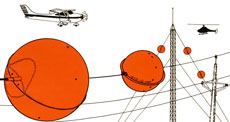 colors to promote awareness and safety. I'm sure you've seen those orange balls on the telephone wires before. Picture to left from Tana Wire Markers: Mark power lines, communication antennas, and guy wires at airport or helicopter areas, river and canyon crossings, overhead obstruction areas, construction sites, migratory waterfowl refuge areas, bird diversion, and more!
There is a whole FAA ADVISORY CIRCULAR AC 70/7460-1K on Obstruction Marking and Lighting. It says any temporary or permanent structure, including all appurtenances, that exceeds an overall height of 200feet (61m) above ground level (AGL) or exceeds any
obstruction standard contained in 14 CFR part 77, should normally be marked and/or lighted. It also specifies the patterns that objects should be painted in, for example:
a. Solid Pattern. Obstacles should be colored aviation orange if the structure has both horizontal
and vertical dimensions not exceeding 10.5 feet (3.2m).
b. Checkerboard Pattern. Alternating rectangles of aviation orange and white are normally displayed on the following structures:
1. Water, gas, and grain storage tanks.
2. Buildings, as required.
3. Large structures exceeding 10.5 feet (3.2m) across having a horizontal dimension that is equal to or greater than the vertical dimension.
Don't worry, I won't reproduce the whole manual here - it is extensive! If one had the time, they could know what size an obstruction is just by the type, location and intensity of the lights...
Monday, December 29, 2008
The Next Installment
 Here is the next picture that I took that day. This is taken toward the runway and shows quite a few features on an airport. Starting from left, you can see the first of two flashlight looking things in the ground, then a stop sign, then a similar, but red, light. These are for vehicles driving on a roadway, which is past the ramp (the concrete in the foreground). The first lights are to alert the drivers to the upcoming intersection - you can see a stop bar painted on the asphalt. I cannot say for sure whether the red light is activated by an approaching or by a person monitoring. I will have to ask around, since I can't find the answer on the internet. I did find a guide for drivers that has some great information for anyone, driving or not: http://www.faa.gov/runwaysafety/asw/downloads/AGVO-guide.doc
Behind the lights, you'll see a sign with a J2 on a black background and a J on a yellow background. If you are facing this sign, it means you are on J (or Juliet) taxiway and J taxiway goes right and left at the intersection you are approaching. Look at this diagram to try and figure out where on the airport we were parked when I took this picture. http://204.108.4.16/d-tpp/0813/05100AD.PDF To the right of this sign (which is backlit so you can read it at night) you can see the back of another similar sign. The front of this sign would have the same two taxiways listed, but in reverse order. In other words, you would be on J taxiway, and the sign would tell you to turn right or left to enter J2 taxiway. By the way, the Air Traffic Controller working the "Ground" frequency would usually tell you which taxiway to take, but if they are not specific, you as the pilot are supposed to determine the most direct route.

You can probably see the blue lights everywhere along the taxiways. An airport at night is a beautiful thing. The lights are also turned on during inclement weather. Looking farther in the picture (you'll have to zoom), you can see the white lights that outline the runway (though there are red ones at the end of the runway). The white 9 on the black background tells pilots that they have 9000ft of runway left. Based on looking at the airport diagram, which runway is it? What other taxiway would you have to cross to get to the "Departure end" of this runway?
 You can see the big white fuel tanks (the fuel "farm") I talked about previously, and an orange windsock. From Wikipedia:
 A windsock is a conical textile tube designed to indicate wind direction and relative wind speed. Wind direction is the opposite of the direction in which the windsock is pointing (note that wind directions are conventionally specified as being the compass point from which the wind originates; so a windsock pointing due north indicates a southerly wind). Windspeed is indicated by the windsock's angle relative to the mounting pole; in low winds, the windsock droops; in high winds it flies horizontally. Per FAA standards, a 15 knot (17mph) wind will fully extend the windsock. A 3 knot (3.5mph) breeze will cause the windsock to orient itself according to the wind. At many airports windsocks are lighted at night, either by flood lights on top surrounding it or with one mounted on the pole shining inside it.
Well, that's probably enough for this edition. More next time!
Friday, December 26, 2008
Ongoing Saga

I've got a few pictures saved up from a day that I flew into Washington, D.C. I have a lot of things I'd like to point out in the pictures. First, note the icecubes flying past the door. The captain was getting rid of the excess from filling our cooler in the airplane!
This was not a good weather day, plus there was something going on in our nation's capitol that day (I can't remember what) so the ramp was packed! A ramp is a parking lot for airplanes.
Wikipedia: An Airport ramp or apron is part of an airport. It is usually the area where aircraft are parked, unloaded or loaded, refueled or boarded. Although the use of the apron is covered by regulations, such as lighting on vehicles, it is typically more accessible to users than the runway or taxiway. However, the apron is not usually open to the general public and a license may be required to gain access.

This airplane ended up being parked just barely off the taxiway, at the entrance to the ramp (it would be towed by a tug immediately after the passengers deplaned). As you can see, there's a pickup truck that brought the ramper out to the airplane, so he was able to marshall the airplane into a parking "space." He then walks out to the wingtips of the airplane and puts down traffic cones - just in case someone needs to be reminded of where the wings ended.
The shuttle is there to pick up the passengers and their luggage. At some airports, you can drive your car up to the airplane (or have someone bring it for you), but at a highly secured airport like DC, this is not possible. And though this airplane is not far from the door, it was raining!
Back to normal

Well, with Christmas over it's now time to get back to normal. For my holiday celebration, I took my nieces to a waterpark. Unforunately, I was planning to bring the 4 and 7 year old. The four year old was sick, so I brought the 3 year old. There was too much of a split in their ages, I think, since I had to stay constantly with the younger, and the older had to go off by herself to do anything at all. Then the seven year old fell ill while at the waterpark. Oh, well, the thought was there...
Posts will be back on schedule!
Monday, December 15, 2008
What's the forecast?

No, not the weather, the aviation industry.
It has been my "feeling" that the aviation industry (read: pilot hiring) is going to get better over the next few years. Why? Because right now the airline industry is struggling and a lot of pilots, getting frustrated, are leaving. Plus many pilots are nearing retirement age. And people are not going to stop flying.
So the demand is going to stay the same, or likely increase, while the demand goes down. Those pilots that stick it out during these tough times will benefit from their dedication.
That's my idea, anyway. I have looked several times for information supporting or debunking my theory, and find it hard to find. This morning I saw this article:
Unfortunately, I tried to search for both the ABC and US News articles, to no avail.
What are your thoughts? Make a comment here.
It has been my "feeling" that the aviation industry (read: pilot hiring) is going to get better over the next few years. Why? Because right now the airline industry is struggling and a lot of pilots, getting frustrated, are leaving. Plus many pilots are nearing retirement age. And people are not going to stop flying.
So the demand is going to stay the same, or likely increase, while the demand goes down. Those pilots that stick it out during these tough times will benefit from their dedication.
That's my idea, anyway. I have looked several times for information supporting or debunking my theory, and find it hard to find. This morning I saw this article:
Good Opportunities In Aviation? It's A Tough Sell from AvWeb
With Boeing, Textron, Cessna, Cirrus, Piper and Mooney either cutting back workers, hours, or operations, it's hard to see beyond the recession to a time when skilled aviation personnel will be sorely needed, but advocates say that day is coming ... maybe sooner than you think. The trick is that the predicted drought isn't the result of an economic boom or bust, but has to do with a generational shift. "The aerospace and defense industry does not have nearly enough skilled workers, especially engineers, to replace the ones approaching retirement," according to an ABC, San Francisco, report. U.S. News Friday expanded that argument to include pilots, stating in its "Best Careers" section that the outlook for employment of aircraft pilots and flight engineers is expected to grow 13 percent through 2016, and keep pace with the average growth for occupations on the whole. The foundation of that article hinges on information provided by a publication by the Bureau of Labor Statistics that appears to have been collected prior to 2006 but, pilot retirements have long been expected by many industry analysts to be one driving force for a shift in supply and demand. Meanwhile, a recent article published by the Hartford Courant states that at least one flight school in the northeast "has seen an increase in demand for its services, particularly flying lessons" currently and in spite of the economic downturn. However, with that increase has come a shift. "There's been an increase in students over 50," the article states. No one should expect those new pilots to be seeking careers in the cockpit, so theoretically those future jobs created through airline restructuring, the expansion of regional services, the economics of smaller aircraft and air-taxi travel and the expansion of global shipping are all expected to contribute to demand. But there are some oddities in the numbers.
According to FAA statistics quoted by the Courant, there has been a 27 percent increase in student pilot starts over the past five years. It should be noted that for whatever reason, that increase has been limited to the Eastern United States. Nationwide, the number of pilots fell three percent over the same period suggesting a trend that would not be matched by any expansion of the aviation industry.


Unfortunately, I tried to search for both the ABC and US News articles, to no avail.
What are your thoughts? Make a comment here.
Saturday, December 13, 2008
Earth's Shadow

Last week while on tour, I had a perfect view of the shadow of the earth. Yeah, and I wasn't in outer space or anything!
We were flying from out west to the northeast, and as the sun set behind us, the shadow of the curve of the earth was reflected on the atmosphere above. Unfortunately, I didn't have my camera right there, even if I would have been able to make it work. So here's some pictures of what it looked like, courtesy of http://www.chitambo.com/clouds/cloudshtml/earthshadow.html. Believe it or not, there are still people who believe that  the earth is flat!
the earth is flat!See this response to a post with a picture of the shadow of the earth (like the above):
Observing Earth's shadow
Well, the "shadow of the Earth's curve" is a nice guess, but I don't think there's anything that can prove that it's actually the Earth's shadow. It could just as well be the sun reacting oddly to the rest of the sky. I mean, we see sunsets all different colors; seeing purple doesn't really prove to me that it's the Earth's shadow.
This is actually a very interesting site. Just go by their FAQ pages for assertations such as:
General / this forum
Q: "Is this site for real?"
A: This site is real. There are members who seriously believe the Earth is flat. However, there are also members who do not.
Q: "Why do you guys believe the Earth is flat?"
A: Well, it looks that way up close. In our local frame of reference, it appears to take a flat shape, ignoring obvious hills and valleys. Also, Samuel Rowbotham et al. performed a variety of experiments over a period of several years that show it must be flat. They are all explained in his book, which is linked at the top of this article.
Also:
The stars are about as far as San Francisco is from Boston. (3100 miles)
Q: "Please explain sunrises/sunsets."
A1: It's a perspective effect. Basically, the sun is just getting farther away; it looks like it disappears because everything gets smaller and eventually disappears as it gets farther away.
A2: As the warped light intersects with the earth, a spectator further away is too low to see the light rays that didn't hit the ground and cannot receive light through the Earth.
Q: "Why are other celestial bodies round but not the Earth?"
A: The Earth is not one of the other planets. The Earth is special and unlike the other bodies in numerous ways.
Tuesday, December 09, 2008
The Windy City (no, not Chicago)
 This is the view outside of my hotel window yesterday morning. The sun was just coming up, and I was keeping an eye out for good weather conditions to go running by the river. However, the American Flag was my weather vane, and it was straight out due to winds. This would be a great tail wind going, but a 20 kt headwind returning! I ended up running on a cheap little treadmill. Bummer.
This is a picture I took at this same airport earlier in the year (when it was warmer!). Pretty neat view out of the window of my ride.
What aircraft is it? Hint: it's faster than my airplane.

Some specs:
General characteristics
Crew: 1
Length: 53 ft 4 in (16.26 m)
Wingspan: 57 ft 6 in (17.53 m)
Height: 14 ft 8 in (4.47 m)
Wing area: 506 ft² (47.0 m²)
Airfoil: NACA 6716 root, NACA 6713 tip
Empty weight: 24,959 lb (11,321 kg)
Loaded weight:
Standard: 30,384 lb (13,782 kg)
On CAS mission: 47,094 lb (21,361 kg)
On anti-armor mission: 42,071 lb (19,083 kg)
Max takeoff weight: 50,000 lb (23,000 kg)
Powerplant: 2× General Electric TF34-GE-100A turbofans, 9,065 lbf (40.32 kN) each
Sunday, December 07, 2008
The Big Hoax: Aircraft Loses Wing, Lands Safely
A video of an aircraft losing a wing and landing safely made the rounds many times over the last couple of weeks. I'll have to admit, although I looked at a bit skeptically at first, I thought to myself that many airshow pilots pull maneuvers I think are impossible so... But this video debunks the authenticity of this stunt.
I don't know why the videos aren't automatically loading, but just in case here's the link:
http://www.youtube.com/watch?v=I89EMDZ0dsc
And from the checkride post: http://www.youtube.com/watch?v=y7uzzh07YOY
Saturday, December 06, 2008
Mystery Picture

Ok, I give up. Usually I enjoying taking pictures of things and then researching their use/origins - I learn a lot this way. I can't get anything on this one, though. Other than assuming this protrusion is for a radar; what is this? Looks like Pinnochio!
Friday, December 05, 2008
What a pilot checkride is like...
One interpretation of the stress, akwardness and uncomfortable-ness of a checkride...
Wednesday, December 03, 2008
Congratulations, Amy!

Have you met Amy? She is the winner of the 2nd Annual Girls With Wings Scholarship - $1000 to use for flying lessons toward her private pilot's license! You can read her application essay, but let me just say, she nailed the pre-requisites. The deadline was November 1st, and Amy found out she'd gotten it via the Girls With Wings eZine. She was a little excited...
We received some incredible essays, which were to include a photo, stating why the applicant believes she is a role model for Girl With Wings™, to include her motivation, inspirations and future plans. Some essays captured this requirement with humor, some with a sad story; unfortunately some did not address this issue at all. Ultimately, the winning submission was judged on her willingness to be a superlative GWW role model. She shows potential to continue her interaction with the GWW organization, via the website and events, so she assists GWW in encouraging more young girls to have an interest in aviation. The only prerequisite was that applicants must not have yet received her private pilot's license.
Amy is 20 years old and also a junior at Dowling College, majoring in Aviation management with a professional pilot minor. "Anyone who knows me can assure you that I have a deep-rooted passion for Aviation. I think about it all the time. It is my first thought in the morning and my last thought as I close my eyes to rest at night." But besides this, she clinched it with "I also try to spark an interest in aviation in other people, not just girls, and share with them what a rewarding, interesting and amazing field it is." She signed herself up for the newsletter, a membership, the message board, in addition to following the application process exactly. Oh, and did we mention this part:
"I am so glad to have found Girls with Wings; it is a great website which unites women who share a passion for aviation and allows a venue for us women to give each other advice, motivation and also share stories.Whenever I am feeling insecure about being able to reach my goals I simply go to the website and I find myself once again motivated and prepared for the next day and all of the obstacles that stand in the way of reaching my goal which will one day prove to be well worth the effort."
A little flattery for the decision board never hurts your chances of success.
If you would like more tips on how to successfully apply for financial aid, please read general scholarship information. Sign up for the Girls With Wings eZine. Please donate to next year's scholarship so we can enable more people to achieve their full potential.
Tuesday, December 02, 2008
Simulator Flyin'
 Ok, I promised a post on the training I did last week, so here goes...
Having been employed by NetJets for six months (actually, having flown the Citation X for six months), I was scheduled for recurrent training at Flight Safety. Depending on the employer, pilots may have to go to training twice or just once a year to keep their skills up. Trust me, there is so much to know about flying that we need a refresher. There are numerous federal and company regulations, weather that changes seasonally or geographically which impacts your flights, crew resource management classes (always a good thing to brush up on), airplane systems reviews, and maneuver practice, etc., etc. And, after all, isn't it better to practice emergencies such as rapid decompressions, engine fire and/or failures and the like while sitting in front of a large computer screen?
One of the contingencies we plan for is a loss of electrical power. On one of our training days (we spent four days in the simulator total), we lost our generators (one pe
 r engine, to include one on the APU). Now, I was just down to the standby instruments (a gyro, airspeed indicator, altimeter, and HSI - or horizontal situation indicator). Imagine going from this:
To this:


And not much else. If you look very closely at the Citation X panel, you can just make out the blue and brown gyro to the left of the captain's PFD or primary flight display. Yes, I know these are the instruments we learned to fly on so long ago, but the point is, that we don't use them anymore. We rely on our Flight Directors, a magenta 'V' bar that gives us guidance (whenever a pilot is slightly disoriented, we tell ourselves to "fly the V bar." Oh, and we use the autopilot a lot.
I actually asked to fly a ILS (instrument landing system) approach with only the standby instruments, and the simulator operator (usually a pilot and instructor) was kind enough to print out my results. The print out is at the top of this post. You can see I had to make major corrections to stay on course (lateral deviations) and glideslope (vertical deviations). Ok, so it wasn't pretty. That's why they call this an "emergency situation."

And there's no fudging on my performance, either. We can go to the debriefing room and see exactly what we did with the power and controls at every phase of the flight, courtesy of a computer monitor.
And yes, everything is topped off with a checkride. A pass/fail, do or die, highly stressful procedure where the check pilot can test you on anything - and since no one is perfect, can fail you at anytime... Luckily I passed, so I can relax - at least until next time!
Monday, December 01, 2008
Post Thanksgiving Push

Well, after a week at recurrent training and a few days with family, I am getting back on track. I will be posting information about the simulator training tomorrow, but for now, I wanted to share a couple of photos from my holiday celebration. To the left are my nieces and nephews, slowing getting out of control at the kids' table. Below is a picture of my brother and brother in law carving the turkeys (one oven baked, one fried). I highly recommend fried turkeys...
 I highly recommend fried turkeys...
The food was delicious and spending time with family was fabulous. It is rare to be able to get 8 adults and 8 kids in the same time at the same place, and I wouldn't be surprised if it never is this good again! There were no fights, no one being grounded, etc., but of course, there are no teenagers yet. I have to go to work Christmas day, so I am happy to have been in town for this Thanksgiving.
I hope your holiday was happy as well. Best wishes for the upcoming season! Lynda
Wednesday, November 19, 2008
Girls With Wings Flying Video
Thanks to Kristine, a Girls With Wings role model, for putting together this video of preflight, takeoff, enroute, and landing portions of her flight. It's a great visual aid for talking to girls about being a pilot.
Oh, and did I mention that Kristine just passed her instrument checkride? Way to go Kristine!!
IF the video doesn't play properly, its also on the homepage of www.GirlsWithWings.com
Monday, November 17, 2008
Fuel Farm

I took this picture on the ramp of one of the FBOs we stopped at last week. As pilots, we usually call these Fuel Farms. I decided to find out what the heck we were calling it that for...
I found out (via Wikipedia, of course) that they're supposed to be called oil depots.
An oil depot (sometimes called a tank farm, installation or oil terminal) is an industrial facility for the storage of oil and/or petrochemical products and from which these products are usually transported to end users or further storage facilities. An oil depot typically has tankage, either above ground or underground, and gantries for the discharge of products into road tankers or other vehicles (such as barges) or pipelines.
Most airports also have their own dedicated oil depots (usually called "fuel farms") where aviation fuel (Jet A or 100LL) is stored prior to being discharged into aircraft fuel tanks. Fuel is transported from the depot to the aircraft either by road tanker or via a hydrant system.
How dangerous is it to have large quantities of fuel this close to airport operations? How are these fuel tanks inspected? Is fire an issue?
Here is an exerpt from a NTSB report on a major fuel fire at the old Denver airport:
EXECUTIVE SUMMARY
I found out (via Wikipedia, of course) that they're supposed to be called oil depots.
An oil depot (sometimes called a tank farm, installation or oil terminal) is an industrial facility for the storage of oil and/or petrochemical products and from which these products are usually transported to end users or further storage facilities. An oil depot typically has tankage, either above ground or underground, and gantries for the discharge of products into road tankers or other vehicles (such as barges) or pipelines.
Most airports also have their own dedicated oil depots (usually called "fuel farms") where aviation fuel (Jet A or 100LL) is stored prior to being discharged into aircraft fuel tanks. Fuel is transported from the depot to the aircraft either by road tanker or via a hydrant system.
How dangerous is it to have large quantities of fuel this close to airport operations? How are these fuel tanks inspected? Is fire an issue?
Here is an exerpt from a NTSB report on a major fuel fire at the old Denver airport:
EXECUTIVE SUMMARY
About 0915 mountain standard time, on Sunday, November 25, 1990, a fire erupted at a fuel storage and dispensing facility about 1.8 miles from the main terminal of Stapleton International Airport at Denver, Colorado. The facility, referred to as a fuel farm, was operated by United Airlines and Continental Airlines. From the time firefighting efforts were initiated immediately after the fire erupted until the fire was extinguished, a total of 634 firefighters, 47 fire units, and 4 contract personnel expended 56 million gallons of water and 28,000 gallons of foam concentrate. The fire burned for about 48 hours. Of the 5,185,000 gallons of fuel stored in tanks at the farm before the fire, about 3 million gallons were either consumed by the fire or lost as a result of leakage from the tanks. Total damage was estimated by United Airlines to have been between $15 and $20 million. No injuries or fatalities occurred as a result of the fire.According to FAA regulations:
United Airlines' flight operations were disrupted because of the lack of fuel to prepare aircraft for flight. Airport facilities, other than the fuel farm, were not affected by the fire. The duration and intensity of the fire, however, raised concerns about the ability of airport and local firefighters to respond to a fuel fire of this magnitude. The origin of the fire also raised concerns about the safety oversight and inspection of fuel farm pumping operations.
22. Do fuel farms not located on airport property serving the airport need to be inspected for fire safety in accordance with Part 139.321? If so, how far away from the airport would this requirement apply?No. Part 139.321 fuel fire safety requirements are specific to fueling operations on the airport. Under Part 139.5, an airport is defined as 'an area of land or other hard surface, excluding water, that is used or intended to be used for the landing and takeoff of aircraft, including any buildings and facilities.' Buildings and facilities included in this definition are those adjacent landing and takeoff areas that support aircraft operations. While an off-airport fuel farm is a facility that supports aircraft operations, if it is off airport property, it is considered outside the scope of Part 139. However, any fueling trucks that use such off-airport fuel farms and come onto the airport must be inspected under Part 139.321.
Subscribe to:
Posts (Atom)